Day 1 | Monday 28th | Winchester – Hyden Wood | 33.6km
Ah, the South Downs Way. This trail for some reason or other has captured my fancy for some time, and I have no idea why. On paper, there is nothing spectacular about it. It is a 160km trail going from the small English town of Winchester, to the small seaside town of Eastbourne. There is no grand traverse like you find in the Swiss Alps, nor is there the sweeping wilderness like you find in the Highlands of Scotland, the NZ Southern Alps or in the other wild places of this world. No, I think what really captured my imagination about it was the lack of all this, but instead it presented itself in my mind as a soft, calming walk through the English countryside. Patchwork fields, tumbledown ruins and gentle rolling misty downs. Doesn’t that sound like the perfect holiday?
I was doing this trail with my friends, Sevi and Elise from the TA (second paragraph, and the TA is already mentioned!). Or, I was meant to. Elise unfortunately could not join us for the full walk in the end (but for wonderful reasons!), so it was just going to be me and Sevi for the entire 160km. Gonna be fun!
We were due to meet up with each other at the trailhead in Winchester. ‘Trailhead’ – it was the cathedral. So, as per my usual lax standards when it comes to prepping for a hike, I did a resupply the Sunday evening before, in Portsmouth where I was staying with my uni mate, Joel. Porridge, the cous, soup packets and wraps and more peanut butter and Nutella. And some fresh food for the beginning too. Life is a dream, I promise you.
Monday morning dawned, and I left Joel’s and caught the train to Winchester. Direct, non-stop. As ever, that one Paul Theroux (I think?) quote rang through my brain as I was on board with the daily commuters with my backpack and dusty shoes. Arriving into Winchester, I was expecting a small town. But no, it was still a 40-minute walk to the cathedral from the station, jeez. Therefore, I caught the bus from the station to try and still be on time for the rendez-vous avec Sevi and Elise. Sure enough, before long, I arrived at their hotel, right beside the cathedral at 08:10. Only ten minutes late. Not quite fully Swiss yet…
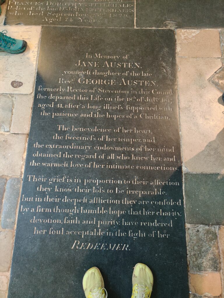
We embraced in the warm spring sunshine. We hadn’t seen each other in a long time. Actually, probably since just after the GR20, when I bumped into them at EPFL and when I had proposed the idea of a long hike to them both! I dropped my pack off in their hotel room, and then we wondered into Winchester central to go see the cathedral. It was a massive thing, all the cathedrals down south tend to be. For instance there is Canterbury and Salisbury as well. This is a very large cathedral in a (relatively) small town too. Usually, we were not allowed to enter the cathedral, not without paying an admission fee at least. However, it seemed like there was a prayer session (I don’t know the official word) going on in some secluded part of the church, and as such, the doors were just wide open for us to wander in and have a look about. Pretty cool. I did get in trouble though for touching the piano and playing a few notes. Whoops. We also saw Jane Austen’s grave. That was rather unexpected. Anyways, a final resupply for Sevi (getting a cursed salami sausage thing) before we headed back to their hotel and picked up our packs. Time to set off!

As I have mentioned in previous posts, the first steps of a new trail are always a special, holy thing for me. Getting into the right headspace, the building of anticipation over the last several weeks/months. The conclusion of all the planning. I still maintain that getting the to trailhead and heading off is one of the biggest challenges of thru-hiking. More than half the battle. The rest is easy in comparison. Just one foot in front of the other really.
We headed out of Winchester along some roads, and out through the back suburbs, following the National Trail acorn waymarkers, showing us the way. Red brick houses and left hand drive cars. Sycamores and oaks bending over fading walls. Elise was with us for the opening stretch. She said that she was going to turn back when we got to the first major hill. We had lots of catching up to do, it was wonderful to be buzzing along, chatting away with each other. Did we take some wrong turns at the beginning because we were distracted? Absolutely. Did it matter? Absolutely not.
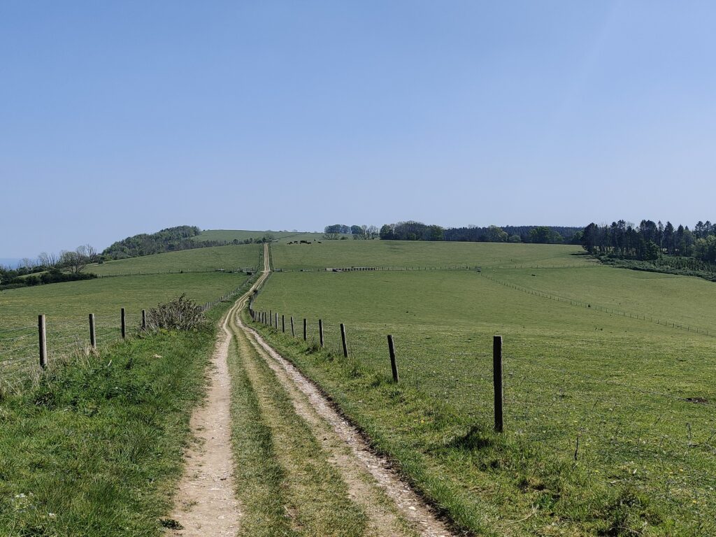
Heading out of Winchester, we crossed the busy M3 motorway and then entered the Downs proper. For this hike, Sevi and Elise had done the proper thru-hiker thing, and had bought the map on FarOut. I had done the proper British thru-hiker thing, and brought along a Harvey’s paper map. Still the best producer and collection of maps in my opinion. I also had to explain to them what a ‘Down’ was… Essentially a set of low rolling hills set in England, covered in grass and with very few trees. This was my description at the moment, but I looked it up afterwards and apparently, they are also typically made of chalk. White was evident immediately since all the paths and fields had white soil and rocks, not mud brown.


The start of this section through the Downs was wonderful though. The weather was a searing blue sky above us, the start of the driest spring in British history, or something climatic like that. Fields stretched to either side of us, separated by hedgerows and trees, floating in the wind. Classic, soft English countryside. Something you would find in a Constable painting. The soil under our feet was white and filled with large chunks of chalk. Kinda cool to walk along for sure. Unique. Genteel.
We strolled along, hats on. My sun hoodie once again doing a solid shift. I am really falling into the thru-hiker cliches though, slowly slowly. First ultralight stuff, now sun hoodies… What’s next? Smart water bottles, and no Nalgenes? Or a hiking pole tent? Gods above.
We arrived at the first ‘big’ (again, I say ‘big’ because the highest point on the SDW is still lower than the lowest point in Switzerland) hill called Telegraph Hill. Elise had originally said that she was only going this far, but we now found out that she lied, since she was keen to push on to the next one, Cheesefoot Hill… What a name! We paused here to have a snack and to bid Elise ‘au revoir’. This is also the moment I realised that I had, once again, forgotten my spoon at Joel’s place back in Portsmouth. Can you imagine my absolute horror!? I once again would have to scrounge for a wooden spoon and live off of that. The stuff nightmares are made of, I swear. My blood runs cold, even now as I sit here and write about it!
Elise turned back, and Sevi and I got going again, motoring now. We headed along, and the nature of the South Downs Way became clear to us. We passed through early springtime fields, shoots and sprouts climbing up through the rocky white soil. We opened and closed creaky, weatherbeaten wooden gates. We hid ourselves from the sun under dappled trees, swaying in the northerly breeze. And all the time, the ground sloped in all cardinal directions, never truly flat. We arrived at Holden farm and helped ourselves to some local Jude’s ice cream (gotta love local produce!) and where I managed to snag a wooden spoon (I can already hear the Cows laughing at me), before we turned back onto the trail and continued along.


It was a relatively empty trail so far, only a handful of bikers cycling up and down past us. But not too many hikers. We had been told by the lady at Holden Farm that there were a couple guys ahead of us, but for the entire trail, we did not see a single sign of them. I reckon she made them up to try and make us feel less lonely. Maybe. We did meet some volunteers fixing and maintaining the trail though! This would be a really cool thing to do one day for sure, I would love that. I have probably said before, but I have a rough dream of living right beside one of these long trails and having an honesty café with baked goods and cold drinks for hungry hikers, and helping to maintain the trail. Soft dreams; honest dreams.
We soon found some shady trees and sat down for lunch. Wraps, melted peanut butter and banana chips. What’s not to love? No cooking, no broccoli. Sevi had his salami and wraps too. Wraps are just great hiking food. Anything can go in them, even noodles (if you believe hard enough!).
We continued on to Beacon Hill (there are many hills called this, just a heads up), sitting at a lofty 201m above sea level. Weak knees thinking about it!… Haha, but yes, we found the beacon alright. From here, we could see all the way to Southampton with the commercial freight docks, and make out the Royal Navy dockyards at Portsmouth too. The sea was a glimmering blurry line on the horizon. We dropped down off of Beacon Hill, through fields of yellow flowering plants, before we skirted round Exton. Thatched roofs and lichen covered graveyards. Birds chirping and overgrown hedgerows.


We passed through Exton (where all the houses are protected by the CIA) and climbed out of the other side, up Old Winchester Hill. No idea why it is called this. This was actually kinda a brutal climb in this early-afternoon heat. Mid 30 degrees Celsius can make these climbs quite energy sapping! There was an old Iron Age Hill Fort at the top, which always sounds more impressive than it actually is. Or, at least, it sounds impressive, and then you see it and you’re initially kind of disappointed, and then you stop and really think about it, and you realise how amazing it actually is. At least, that’s my general trend when confronted with these sorts of things. We passed an old couple near the top as well. I would love to still be climbing these hills when I am in my eighties. Would be amazing to still be that active.
The Old Iron Age Fort was dated to about 4000 years old, and was evident from the number of barrows all around the summit. This was the only evidence honestly. Still, pretty darn cool in my opinion. To think that people used to live here, farm here in truly wild England when rainforests (yes!) covered the land still, unthinkable in nowadays society. And yes, point aside but the UK used to be covered in rainforest. Not the Amazonian, Hollywood rainforest. But more like Pacific Northwest rainforest. Victorian era aristocracy, and the industrial revolution decimated them though.
We swung around the side of Old Winchester Hill and made our way down another shallow vale and across to Whitewool Farm. We bumped into some hikers just outside of this farm, the first hikers we had really seen so far, heading the opposite direction. A couple in their forties or fifties I reckon, they were just out sauntering around the Downs doing some training for the Southwest Coastal Path. Excited for them! I cannot wait for my next section of that hike for sure! Just past the farm was a fishing spot and café where we sat down and had some cold drinks. It was truly roasting outside. So far, the colour palette for this hike was sky blue, spring green and chalk white. Spoilers, it would stay this way.
Final push of the day, we up and left, heading up and over Salt Hill and descended down past the sustainability centre, walking along the road at one point. We were wanting to wild camp, and as such, we needed somewhere hidden to do this. After all (and once again), wild camping is not allowed in England. It is tolerated along these sorts of trails, as long as it is done responsibly. As in, follow the ‘Leave no Trace’ guidelines: ‘take only photos, leave only footprints’. We planned to camp in Hyden wood, and indeed, we found that it was suitable for us! It was broadly flat, mostly speaking. The big issue was that it was separated from the path by a barbed wire fence. As such, we walked along and along and along until we finally found a place where the old fenceposts had disintegrated enough that we could climb under the barbed wire fence (taking good care of our packs!) and scamper into the thicker, darker, deeper parts of the forest to find a place to pitch up. Within fifteen minutes, we had found our place, sheltered on two sides by fallen trees, but with clear flat ground to pitch on. Amazing. The evening was spent cooking our meals, before heading to sleep. We were undisturbed absolutely. A couple bikers passed the trail to the north of us, but apart from that, not a single person or animal. Birds flitted about in the branches above us, and sleep took us before long.


Day 2 | Tuesday 29th | Hyden Wood – Glatting Beacon | 36.0km
Sevi is a very efficient guy when it comes to pitching and camp stuff. We were up at 06:00, and ready to leave at 06:50. Practically a record. But a major component of Sevi’s efficiency comes from the fact that he (and Elise) don’t eat breakfast on the trail! Instead, he chowed down on some snack bars throughout the morning as we hiked along. No wonder he and Elise can cover monster distances! This is probably a big PCT mindset though, most likely! If/when I do the PCT, I wonder if I will follow these trends too… Hmm…
We crossed the barbed wire fence again, and headed back onto the bridleway path. There was dew on the ground, and the sun was just setting the day alight. Fire on the horizon, mist rising. We crossed broad Tegdown Hill and headed on over Hillhampton Down too before we strolled down a rough fairway and into the Queen Elizabeth Country Park. And could we find water anywhere at all along this stretch? Absolutely not. None of the shelters or public bathrooms were open at this time in the morning yet, and the visitor centre at the Country Park was still closed as well. Sucks to suck. We had each 0.5L though, so we decided to just barge along anyways and see where life took us.
We headed, undulating, along the Downs, through farms. Fagg’s Farm, Coulters Farm, Sunwood Farm, Foxcombe Farm… Classic English names it seems, undiminished by time. We strolled through them, one after another. We actually came across some trail magic as well, a girl called Skye who had just passed her driving test and was selling flapjack on the trail to help raise some money for a car. There was also water here, so we could top up easily. Over West Harting Down, Tower Hill and Harting Down, we stomped along under the hazy blue-white sky, dark green new growth in all the fields about us. Simply lovely. At Tower Hill, we saw this crumbled ruin atop of it and I was excited to go and explore it. Ruins (of castles especially) have always attracted me. However, it was fenced off, unfortunately, with warning signs about how dangerous it was. Health and safety, pffff. I don’t believe in it, people should learn how to deal with risk (within reason, of course).

We crossed over Beacon Hill, headed round Treyford Hill before finding a shady, hidden spot just off of the path where we sat and had our lunch in relative coolness. Dog walkers and families passed us, walking small stretches of this wonderfully calm trail. Didling Hill and Linch Down followed, and here we finally met another hiker. He was an elderly gentleman who was bombing along, faster than us for sure. Looking at him, you could tell that his name was like Kenneth or something. You know how sometimes you can just look at people and see a name that just sort of suits them? Yeah, this is what I figured. He overtook us, but he was staying at BnBs along the way so I believe he was diving off of the trail for the day at Cocking, the next ‘large’ town just off of the trail.

We dropped down off of the side of Stead Combe where we stumbled into the coolest chain of cafés, Cascade Clubhouse Café (CCC). They were situated all the way along the Downs, and along this trail. We had missed the first one somehow, but there were several other ones that we would come across along the way. We settled down for a toasty and cold drink. There were plenty of people there, having ice creams and late lunches. There were two old people who were out for a day together evidently, sat closest to us. They were complaining about lawyers and how expensive they are for the entire time that I ate my toastie. When they got up to leave, the gentleman said ‘Now promise me one thing. When we go shopping, you need to buy one healthy thing’ to which the lady replied ‘Oh alright then, but promise me we’ll play backgammon this evening. I’ll whomp you.’ I couldn’t help but laugh and smile at this exchange.
We continued buzzing along, chatting about all sorts of things, our minds relaxed. We discussed all sorts of things these days. The difference between Switzerland and Scotland. The unique schooling system in the UK, and how each canton in Switzerland has a different curriculum, approximately. The difference between public and private land and the difference that has on hiking and the outdoors. Plenty of interesting stimulating conversation for sure. We passed some hikers going the opposite direction who were training for Hadrian’s Wall hike. So again, I talked to them about that since I have done that one too.
Graffham Down and Woolavington Down came and went before we got to the second CCC of the day which was closed by the time we arrived. Shame. There were some Dutch cyclists also thinking the same thing. Another great option for the SDW is the fact that it is accessible to the whole variety of activities, so you can bike-pack the entire thing, or do some horse-trekking. It’s amazing! These Dutch cyclists were doing it as part of a larger trip along the south coast of England.


Leaving behind the CCC, we passed through Littleton Farm and headed up Sutton Down, towards Glatting Beacon. It was pitching in at around 18:00 by now, and we were wanting to find somewhere to head to sleep soon. I think our feet were feeling it. Also, for this entire stretch, we spoke in French alone which was good practice! At the top of Glatting Beacon, we found some empty fields and woods where we could potentially pitch up without anyone being aware of us. We both did a bunch of exploration before finally settling on a place in amongst the trees, just off of the main path, below the main trail. It was also warm enough that actually, we decided to not to pitch the tent but instead we just cowboy camped. First time I have done that!… Except for that one time in Greece when I was 14. We laid the groundsheet for my tent out and we both settled down for the night. I think I was super nervous about doing this, there is a certain vulnerability to just sleeping out in the open like this. However, in the end, I was soon falling asleep, warm in my sleeping bag. Not a cloud in sight. Stars bright and twinkling.
Day 3 | Wednesday 30th | Glatting Beacon – Saddlecombe Farm | 39.2km
Honestly, for my first time cowboy camping, it was not the best. There was a dog barking at around 04:00, and I was just in a general state of paranoia for the entire night. Sevi did whisper a question in that inky-grey dawn, asking if there were wild dogs in the Downs. I did not know. But at night, your mind makes up all these fears and exaggerates all these things, which meant that I (we?) was convinced that we were surrounded by rabid dogs. However, in the light of the morning, I thought back about how silly those thoughts had been. Of course there weren’t wild dogs in the domesticated South Downs! Pffff, it was probably just some foxes or some such.
Sevi got up at 05:15, deciding that he couldn’t sleep anymore. Since there was no tent, he was packed and gone within twenty minutes. Meanwhile, I got up slightly later, 05:45, when I too conceded the sleeping game and just decided to head on out. It was a quick pack up, and a nice breakfast in the rising sun. Really wonderful actually.
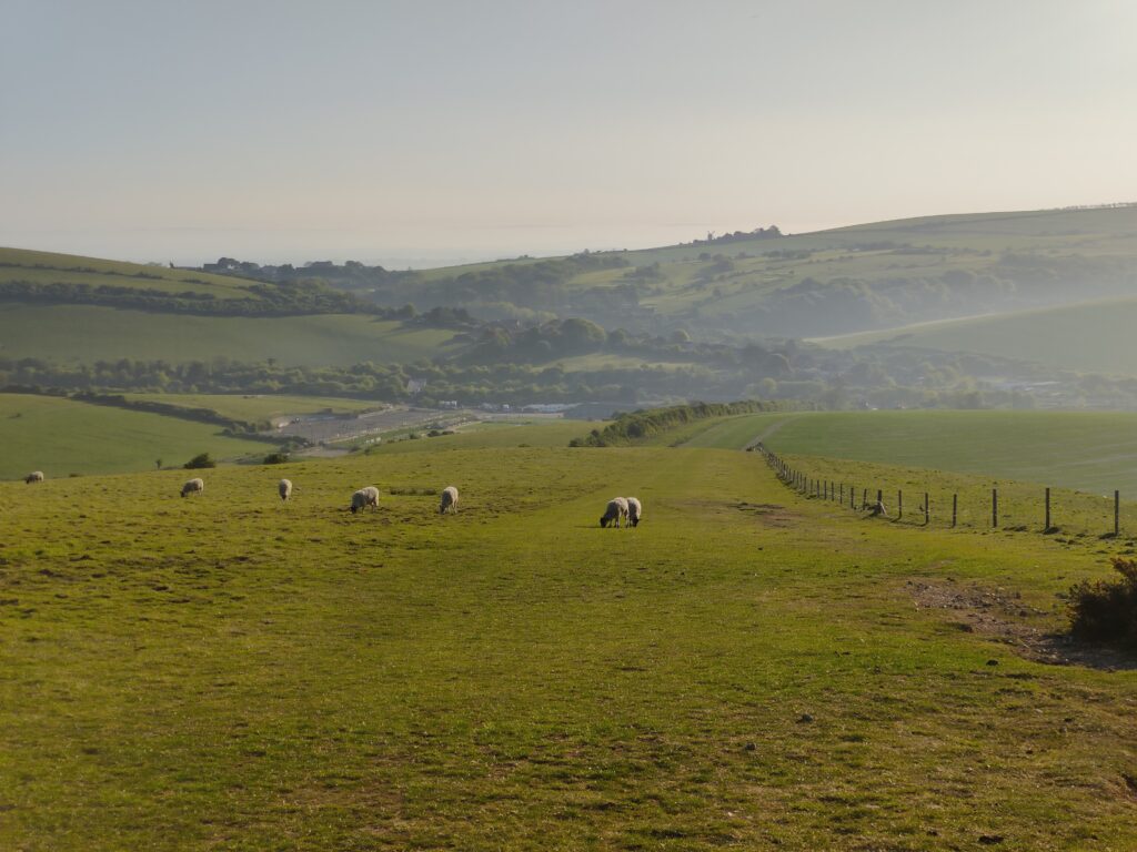
Crossing Westburton Hill, the Downs stretched off ahead of me. The morning was hazy, as it had been every morning so far, promising another baking day under a scorching sun. Shades of farm green and sky blue washed together and were hung out to dry in the rising sun. For now, I made the most of the cool morning. Dew covered grass glistened like jewels, drops of silver. Cows were to my left, and sheep far away to my right, and here I am stuck in the middle with my shadow, on this chalky white path. The trail followed the ancient fences, over and over the Downs.


I passed over Westburton Hill, crossing paths with many early early runners, dog walkers and bikers, and dropped down through Combe Wood until I arrived at a rare flat vale floor where the River Arun ran down towards the sea. Reeds grew by the banks and there were small settlements away to my right. Smoke, curling in twisting runes, rose up into the pale blue sky. I avoided the thatched roofs and crossed the Arun and train line (I waved at a passing commuter train, it honked) and pushed on and up the next Down. Amberley Castle was to my left, Arundel Castle to my right. English? Yep. Crenelations like teeth bared in an outdated smile.
Pushing on to the top of Rackham Hill, I left the sleeping villages behind and was again in amongst the quilted, patchwork fields, looking out across undulating Downs and passing through medieval woods. Tunnels of trees with accompanying birdsong. A soft swaying breeze from the Channel. It was only day three, and I was pushing to catch Sevi (who, remember, had left about an hour before me), but the Downs really were beautiful. I can see why people fall in love with them. We humans, we have a special connection to the soil and the earth. We fall in love with landscapes very easily. Soft or grand. And in fact, a lot of our language is based around geography. Our spoken culture is literally rooted in the land. Which is why, in this day and age with urbanisation, language is being lost as more people move to the cities and nature is forgotten about. It is sad. I recently got a book by Robert MacFarlane which discusses this phenomenon exactly. I should probably read it, be more informed. Hmmmm… I’ll start peppering my future posts with some old, forgotten words! Haha


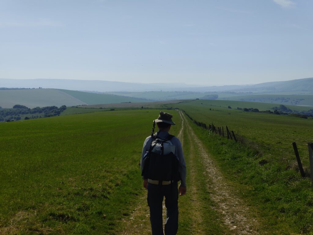
I crossed Springhead Hill, Kithurst Hill, Sullington Hill and Barnsfarm Hill. So many hills. I should count how many named hills we crossed actually! Eventually, after wandering (‘Not all those who wander are lost’; JRR Tolkien) nonstop for a while, I eventually caught up with Sevi, right before our scheduled rendez-vous. Or, in other words, right before the busy busy A24 (not the producing company, the road). It was now late morning and I could hear all the traffic down below us. We descended, walking along some solid pavement and concrete, filled our water bottles at a well placed tap, and then scampered across the A24. Oof. We compared our mornings, talking about the silence and our own thoughts. I think we both appreciated the time to ourselves because up until then, we had been chatting away at a rate of knots since Winchester.
The Downs continued, relentless under the sun. Up, down, up, down. Beautiful. Up at the top of Chanctonbury Hill, we passed Chanctonbury Ring, another prehistoric hill fort where a lot of people were sheltering (sunbathing, picnic-ing, reading) under the trees now growing there, looking north over the lowlands of West Sussex. Harry’s land. We talked about the PCT and about Sevi’s work. Industry seems like a good place to be, if you find the ‘correct’ industry to be in! Maybe I will end up there one day… Maybe not. Who knows!


The trail skirted round the town of Steyning, and we had to cross several roads. There were even some official National Highway signs alerting drivers to us South Down Way walkers! Abruptly, the trail dived off orthogonal to the road and up a scraggly white trail to the top of Annington Hill before we tumbled down the other side. At this point in time, my knee was vaguely starting to let itself known, never a good feeling for a walker. And because I am a type of person who obsesses, once I feel something wrong with my body, I will constantly think about it non-stop for the rest of forever. Unless it gets better, that is. We found a small roadside café, the Fodderbox, where we grabbed some ice creams, and then continued on our way, up onto the Downs again.


The hills ticked by. Beeding Hill, Truleigh Hill, Perching and Fulking Hill. Green grass, thin fences and milky white trails. It really was just ‘copy and paste’. Sevi said that he found this actually incredible pleasant, so easy going and exactly what he wanted with a hiking holiday. And I am in agreeance with him. As I stated at the beginning, something that drew me to this trail was the idea of peace and quiet, no majestic grand Alpine vistas. It was peaceful and contemplative and encouraged profound thoughts haha
At the top of Fulking Hill, we passed a shiny, brand new 4×4 parked on the crest, with a marquee tent thing set up on the side. There were a bunch of cameras and sound people. They were shooting an advert. And as we passed this tent, I heard the director saying ‘We want lots of energy guys’, and glancing at him, I saw him gesticulating with a massive whip in his hand. Hmm, great boss! There was also a Tamaru tent pitched (imperfectly) at the side of this fancy car. I have not heard of the brand Tamaru before. Hmmm… See! This is the power of advertising. This is what was being advertised to me. All adverts are subjective after all…
After this advertising campaign, we spied a bunch of buildings and thought that this was where we were headed for the evening, Saddlecombe Farm. However, in the end, it turned out to be pub, the Devil’s Dykes Inn. Well… Guess we had a couple more kilometres to go then! We dropped down off of Fulking Hill, through the Devil’s Dyke (which was just a nice narrow vale filled with gorse) and arrived at Saddlecombe Farm for real. We should probably take a map reading course. My knee was still a bit stiff and a touch sore, so I was glad to stop for the day. We had nearly done 40km as well! We crossed into the farm and met the farmer Roly, who was renting the property and land (is… that how farming works?) and who guided us into one of his small empty fields where we could pitch our tent. No WiFi, no showers and barely much hot water. No café or food (we arrived too late), and no phone signal. But it was a wonderful setting nonetheless and we were the only ones there. I ate dinner twice that night, I was so hungry. And, I had enough food for that. Sleep arrived at the same time as hiker’s midnight.
Day 4 | Thursday 01st | Saddlecombe Farm – Bostal Hill | 38.2km
A beefy day yesterday, and we were feeling it. Still, the campsite was only us!… And the farm dogs, that woke us up before 06:00. I guess that is as natural of an alarm that you can get! Other than a cockerel. We packed up, breakfasted (or, at least, I did) and then left the farm. Goodbye nice campsite. Ciao ciao.
We turned right out of the farm gates and up Templar Hill. My knee was behaving again, thank goodness. These temporary pains and aches are always alarming to me because I so infrequently had them! Maybe it is a sign that I am getting old? Quelle heurrer!
We crossed another busy road, and headed through Pyecombe Golf Course. At this point, I had to explain the game to Sevi because it seems to only be played by British and Americans mostly. We were passed by some elderly sisters (I assume) who were running altogether. And running slowly. It would be cool to run this route one day I think. Totally doable, with a support crew.
After crossing Ditchling Beacon, we stopped at the Pink Pit Stop for a small break. It was closed, so we sat at one of the numerously aligned pink picnic tables and ate some of our own snacks. I think we were starting to feel the multiple 30km+ days, one after another. We heaved ourselves up, put our packs back on our sweaty shoulders, and headed back to the trail. Smooth grass reached gently up the side of these rolling hills, an etched white line guiding our feet. We crossed Western Brow and Streat Hill and across the broad Plumpton Plain. To our left, the Downs fell away sharply, leading off towards towns and villages. To our right, south, they gave way slowly to sheep fields and wire fences. Hay bails and wildflowers.


After passing Plumpton Plain, we turned right along one of the many dusty lanes and headed due south. We were walking in-between fences and hedgerows. The farmers here had evidently let the land start to rewild itself though because all of a sudden, we emerged into these wonderful purple and red, yellow and lilac meadows. Such a change. I ran my hands through the flowers as we passed through these fields, heading downhill and off the Downs for a brief moment. Fantasy realm stuff. It was like that one scene from Gladiator, you know? But with flowers, not corn.


We arrived into Housedean Farm (a campsite!) at the bottom of this gentle decline and got ourselves some ice cream and refilled our bottles from a powerful water tap, drenching ourselves (read, ‘me’). This was a lush farm. We didn’t stay here, but I kind of wished we had! There were actual working showers at this one, and a gym and a sauna. What!? Yeah if I did this trail again (I doubt it), I would push these last several days in order to make it to this camp spot. Totally doable for sure (knee aside).
We crossed the A27, made our way under the railway line and then turned and started making our way uphill once again, up towards Castle Hill. We promised ourselves that we would have lunch at the top here, if we could find shade. The sun was kinda ferocious. It was never this mean in Scotland!… My sun hoody was certainly doing a solid shift these past weeks!


A long slog up and around the ridge of this hill, and we finally found a small divot in the land that was filled with gorse bushes and a couple trees that we could, believe it or not, comfortable shelter under whilst we ate our lunch. Wraps and peanut butter. I also staked the tent out to dry in the breeze and sunshine whilst we ate. Sevi was finishing his cursed salami for lunch. Since Reidso’s incident, I will never be able to look at one of those again with any ounce of trust…
We powered on after lunch, along another set of beautiful, soft downs. Swanborough Hill and Mill Hill were the only ones with trig points/cairns on top, before we could drop down into the smallest of villages, Southease. We met a very dispirited bikepacker as we came off of the Downs, looking completely worse for wear. He was not sure he would be able to do the rest of this trail with the amount of elevation that there was, and in this heat too… Yeah… I sympathised with him completely, some of these hills – whilst not large – were quite steep and there was just no stopping. We wished him ‘All the best and Adieu’, and then headed into Southease. There was a local pond in this tiny little village and oh my goodness! I caught my breath. The light was just right, that I was reminded of Wind in the Willows. That beautiful beautiful kids book. The idyllic nature of it all… Sevi said at this moment, that the South Downs Way is a collection of the most idealised parts of England, rolled into one. I agree, to an extent. A dream spot.

We crossed the River Ouse and arrived at our first checkpoint of the day where we could stop, Itford Farm Youth Hostel. It was still early afternoon, so we sat down to have a discussion on what to do next. The options were to either continue and push to Alfriston, another 12-15km away. Or stay here, and finish strong tomorrow. Sevi gave Elise a call to discuss the options, since she was waiting for us in Eastbourne, and would be joining us for the last 10km or so. With her on the phone, we decided that the best option was to probably push on for this evening so we could meet up with Elise early the next day and finish for lunchtime tomorrow. Sounds like a plan! Sevi and I therefore filled up with some cake and drinks, and then heavily stood up and headed back out onto the Downs. Those dreamy Downs.
We boosted up Itford Hill and then traversed across this long and continuous spine of the Downs. Beddingham Hill, Firle Beacon and Bostal Hill. We passed a whole load of day walkers all of a sudden. A CEO type lady, powerwalking past us (!!), a father-daughter couple walking in silence, a couple lads from Northern England going the opposite way with their Osprey Exos. A nice hiking community for sure. It was busy all of a sudden!


Arriving at the last (named) hill on this chain, Bostal Hill, I sat on a creaky wooden fence and downed my water, waiting for Sevi. There were some nice open spaces that I had just passed and the idea of wild camping on top of the Downs was kind of appealing to me. The only issue is, is that it is illegal, of course… Sevi rolled up before long and I think we were both thinking the same idea because it was the first thing out of his mouth!
Therefore, having agreed that it would be nicer to stay on the Downs rather than in a campsite, we sat and lay in the grass in the afternoon sun, waiting for it to get slightly dark and quiet in order for us to pitch the tent with no guilty consciousness. When you sit and lay in the grass and throw your phone away and lie there, listening and thinking, a whole new world opens up to you, I swear. You are aware of the bugs and the butterflies. The swaying grass and the rich smell of the earth The alive smell of the earth. You watch ants, tirelessly labouring away and hear birds sing our to each other, hidden in the foliage and bushes perched on the slopes of the Downs. It was one of those dreamy moments for sure, that a mild physical exhaustion helps to promote. Content. At peace. Happy.
Before long, the red sun was below the horizon, and we felt we could pitch the tent, guilt free. We had already eaten our dinners (ramen for me) by the time we set about finding the exact spot. Before long though, the tent was up and we were laying down inside. The tent doors were rolled back slightly to allow a wonderful cool breeze in and sleep stole upon us before long.
Day 5 | Friday 02nd | Bostal Hill – Eastbourne | 20.8km
Despite being happy with the pitch and trying to do it ‘guilt free’, there was some subconscious part of my rule-abiding brain that was stopping me from being properly comfortable! As such, it was a fairly restless night, not helped by a ten minute squall of rain that made us quickly jump into action and close the tent doors.
We were woken at 05:00 by some barking dogs from a (very) early morning dog walker. Since people (i.e. farmers) were evidently out and about, and we were not sleeping too well anyway, we decided to bugger it and get up and be off. We were packed, breakfasted and on our feet heading south-east by 05:40.


And honestly, what a time to be alive, because that sunrise will live on in my brain for a long time. Blood red, grey clouds and mist over sleeping England. What a sight. Think of England, high above the clouds from Pompeii (ft. Bear’s Den).

Since we were at the top of the hill, our day started with a pleasant enough downhill, dropping into quaint Alfriston. It was 06:00 in the morning. All the thatched or slate-tiled pubs and brick-built houses had their lights out and their doors locked. Sevi and I headed through this deserted town and out the other side, along the banks of the deep and smooth Cuckmere River. We followed it down, directly towards the coast, through Litlington and past another CCC café, shut because it was waaaayy too early for any sane person to be awake.
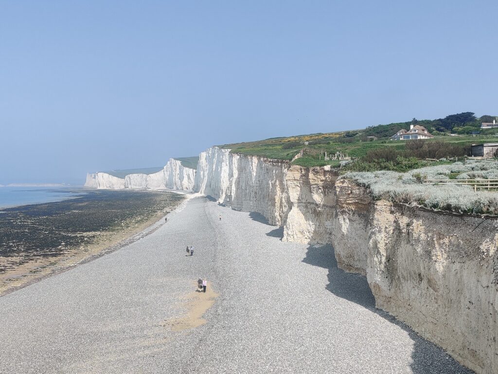
Eventually, having crossed through horse’s fields, along country lanes and through other sleepy settlements, we arrived at one of the main roads leading to Eastbourne. There was a bus stop. And we sat down. Not for us to catch the bus, no no. No, we were just resting our legs as we waited for Elise to arrive. We had covered close to 10km today already, and we had another 10km or so to go yet! However, these 10km were along the Seven Sisters, a spectacular, touristy section of the South Coast!
We eventually saw the bus coming round the corner and before long, there was Elise in front of us, giving us hugs and congratulating us on making it this far, this quick. And she had a point. We had covered about 150km in an afternoon, three full days and a couple hours that morning. I am happy to acknowledge that yeah, we had been machines!
We set off from the bus stop, walking slower now that Elise was with us (sorry Elise!). Up a long winding, white path until we arrived on a sudden cliff edge, dropping dramatically into the cerulean sea. These cliffs, the Seven Sisters. The air was hazy along the coast, and a breeze was moving this haze about, so that it felt super mysterious. We turned left, east, and set off along the clifftops of the Seven Sisters.

Yeah, I can understand why this is a tourist spot, and an iconic movie spot as well. I am thinking of Atonement, of course. As well as other films such as Kevin Costner’s Robin Hood Prince of Thieves (1991). And I am sure there are more, I just cannot think of them off of the top of my head! The cliffs reach eastward, white chalk bare to the elements. And of course, they are – along with the White Cliffs of Dover – a highly symbolic ‘entrance’ to England, and the UK in general. Many troops coming back from WW1 and WW2 would have seen them, and known that they were home. A strong, unwavering symbol of hope, almost, after the horrors of war. Tolkien made reference to these chalk cliffs in his Lord of the Rings novels when, at the most dire point in the books, Gandalf says: ‘The grey rain-curtain of this world rolls back, and all turns to silver glass… And then you see it. White shores… and beyond, a far green country under a swift sunrise’.


So yeah, for me, it was pretty special to see them. Loved it. If I did it again, I only wish that I could sit at the Coastguard Cottages at Cuckmere Haven… Look it up, you’d understand why…
We trawled along the tops of these cliffs, not too close to the edge. The rollercoaster ride that is called the South Downs Way was nearly over, and it was emphasising to us that we would still have to earn the right to finish! So much elevation all of a sudden! We walked along, taking photos, before we arrived into the Birling Gap at the perfect time, for the café was opening! I therefore bought myself a pastie, a doughnut and a ginger beer and before you could repeat my order three times over, they were gone. Stuffed into my mouth. No regrets. And no talking from me with my mouth that full.
We continued on from the Birling Gap, on and on through the growing fog and harr that was rolling in off of the sea. Literally, at points, we could maybe see ten metres in front of us. What a change from the rest of the hike (scorching weather, bottle blue skies, no clouds), it was quite sudden! We came upon a ‘cathedral’ in the fog. Or at least, this is what Elise had been calling it. It was a lighthouse, Belle Tout. Une phare. We headed off round the other side of this looming ‘cathedral’ and before we knew it, it was slowly starting to clear up again as we approached the end of the cliffs. Elise told us that she had a secret place for us where she wanted to show us Beachy Head Lighthouse. However, the harr was still quite thick in places, especially below the cliffs, that when we got there we saw… nothing. Still, she had brought along some chocolate, and so we sat in that soft grass below the trail where all the tourists were, and looked out over the sea of water, and the layered sea of fog.


After maybe half an hour, it really did clear up that we did see Beachy Head lighthouse for sure. Wow! Iconic, once again. And in fact, I had that Napoleonic sea shanty song in my head as a result. You know, Spanish Ladies, describing sailors coming back to England. And how Beachy Head was one of headlands mentioned in the song. I think.
Having seen Beachy Head, we heaved ourselves up and headed down the path to finish the last kilometre or so of the trail. We headed through bushes and neat undergrowth and along tourist-friendly paths until eventually, we arrived a large panel monument that indicated the start/end of the South Downs Way. What a wonderful trail. Sevi and I posed as Elise took a photo, and then that was that. Another trial done; another trail done.

We walked into Eastbourne and headed along the seafront parade, passing grand hotels which had all passed their heydays. A bit cynical, but also a bit true. We found ourselves a pizza place where seagulls perched on roof tops, hunting for unwary tourists with bits of food in their hands. I had a train to London at 14:00. But whilst we ate our pizzas, I noticed a slightly shabby building with peeling paint had some words printed in a ribbon across the top that read: ‘I slip and somehow yesterday turns and today is gone. Still, something remains unsung’. Seems quite deep. I will have to think on it.
(Pssst, by the way 53 named hills along the SDW. Prime number. Nice)